


plan nature 24 février 2019 pas vma

roumyrobert
User
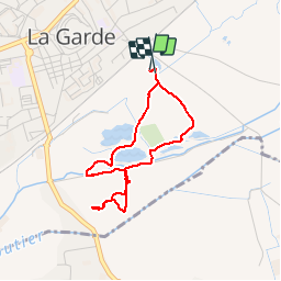

Length
3.4 km

Max alt
26 m

Uphill gradient
18 m
Km-Effort
3.6 km

Min alt
18 m

Downhill gradient
21 m
Boucle
Yes
Creation date :
2019-02-24 09:34:40.993
Updated on :
2019-02-24 10:51:27.935
1h03
Difficulty : Very easy

FREE GPS app for hiking
 SityTrail
IGN / Geographical institutes
SityTrail Plus
The world is yours!
About
Trail Walking of 3.4 km to be discovered at Provence-Alpes-Côte d'Azur, Var, La Garde. This trail is proposed by roumyrobert.
Positioning
Country:
France
Region :
Provence-Alpes-Côte d'Azur
Department/Province :
Var
Municipality :
La Garde
Location:
Unknown
Start:(Dec)
Start:(UTM)
257506 ; 4778791 (32T) N.
Comments